To ensure absolute precision in exploration drilling, the HolePlan computational engine has been rigorously validated against the ISCWSA (Industry Steering Committee on Wellbore Survey Accuracy) Standard Set of Wellpaths (Revision 4). This industry-standard dataset is designed specifically to test the mathematical integrity of drilling software.
In direct comparative testing, HolePlan achieved a 100% (1:1) match with the ISCWSA definitive results for every tested station.
HolePlan utilizes the Minimum Curvature Method, the globally accepted standard for reconstructing a 3D wellbore trajectory from survey data.
Comparison of Northing, Easting, and TVD coordinates against the ISCWSA Reference Well.
1:1 Match. HolePlan's spatial reconstruction is mathematically identical to the industry benchmark.
The "Clearance" (analysis) engine in HolePlan calculates the precise 3D distance between two boreholes.
Comparison against the 11 ISCWSA Offset Scenarios (Parallel, Perpendicular, and Close Proximity).
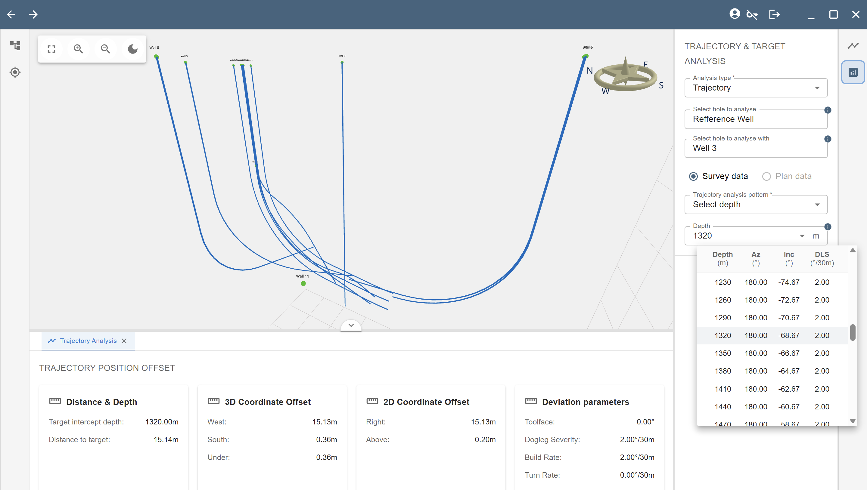
1:1 Match. HolePlan results for 3D Closest Approach (C-C Distance) matched the benchmark data to the fourth decimal place.
Offset 03: East 10 drilled wellpath r4

| Ref_MD | Ref_TVD | Ref_N | Ref_E | Offset_MD | Offset_TVD | Offset_N | Offset_E | Horiz_Bear | C-C Clr Dis | Ref PCR | Offset PCR | Calc hole |
|---|---|---|---|---|---|---|---|---|---|---|---|---|
| [m] | [m] | [m] | [m] | [m] | [m] | [m] | [m] | [°] | [m] | [m 1sigma] | [m 1sigma] | [m] |
| 1320.00 | 1312.66 | -58.99 | 0.00 | 1319.60 | 1312.29 | -58.62 | 15.13 | 88.60 | 15.14 | 2.3667 | 2.3660 | 0.762 |
| 1350.00 | 1340.41 | -70.38 | 0.00 | 1349.55 | 1339.99 | -69.94 | 16.12 | 88.42 | 16.13 | 2.4384 | 2.4375 | 0.762 |
| 1380.00 | 1367.74 | -82.74 | 0.00 | 1379.49 | 1367.28 | -82.21 | 17.19 | 88.23 | 17.21 | 2.5158 | 2.5148 | 0.762 |
| 1410.00 | 1394.63 | -96.05 | 0.00 | 1409.43 | 1394.13 | -95.42 | 18.35 | 88.05 | 18.37 | 2.5995 | 2.5984 | 0.762 |
| 1440.00 | 1421.03 | -110.29 | 0.00 | 1439.37 | 1420.48 | -109.56 | 19.59 | 87.87 | 19.61 | 2.6902 | 2.6889 | 0.762 |
| 1470.00 | 1446.93 | -125.43 | 0.00 | 1469.30 | 1446.33 | -124.59 | 20.90 | 87.70 | 20.93 | 2.7882 | 2.7869 | 0.762 |
| 1500.00 | 1472.28 | -141.48 | 0.00 | 1499.23 | 1471.63 | -140.52 | 22.29 | 87.53 | 22.32 | 2.8940 | 2.8926 | 0.762 |
| 1530.00 | 1497.05 | -158.39 | 0.00 | 1529.15 | 1496.35 | -157.30 | 23.76 | 87.37 | 23.80 | 3.0078 | 3.0064 | 0.762 |
| 1560.00 | 1521.22 | -176.17 | 0.00 | 1559.07 | 1520.47 | -174.93 | 25.30 | 87.21 | 25.35 | 3.1300 | 3.1286 | 0.762 |
| 1590.00 | 1544.75 | -194.77 | 0.00 | 1588.98 | 1543.96 | -193.39 | 26.92 | 87.05 | 26.97 | 3.2607 | 3.2593 | 0.762 |
| 1620.00 | 1567.62 | -214.19 | 0.00 | 1618.89 | 1566.78 | -212.64 | 28.60 | 86.91 | 28.66 | 3.3999 | 3.3986 | 0.762 |
| 1650.00 | 1589.79 | -234.39 | 0.00 | 1648.79 | 1588.91 | -232.67 | 30.36 | 86.76 | 30.42 | 3.5476 | 3.5465 | 0.762 |
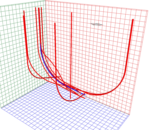
3D Visualization of Wellbore Trajectories

Example of the 1:1 match at a critical safety depth (MD 1320m)
By achieving a 1:1 match with the ISCWSA Revision 4 standard, HolePlan provides explorationists with a verified, professional-grade tool. Users can plan multi-branch programs and monitor complex trajectories with the certainty that the underlying math is identical to the most advanced enterprise solutions in the world.
Source: Industry Steering Committee on Wellbore Survey Accuracy (ISCWSA). Standard Set of Wellpaths, Revision 4. Developed by the SPE Wellbore Positioning Technical Section (WPTS). Available at iscwsa.net