Industry SolutionsPricingGetting StartedResourcesAbout UsFAQ
Contact Us

HolePlan™ is a trademark of Hole Plan Ltd. All software code and 3D visualisation logic are protected under the International Copyright Law. This software is an independent engineering tool and is not affiliated with any hardware manufacturer.

Our Office

Mladost 2, Bl. 221, Ent. 1, Floor 9, Apt. 41

Sofia Municipality, Mladost District

Sofia 1799, Bulgaria

Resources

    Drilling intelligence without bordersValidation of Mathematical AccuracyBorehole Safety & Risk MitigationPress & Media

Support

    SupportTerms and ConditionsPrivacy Policy

Company

    IntroductionAbout UsContact Us
Copyright © 2026HolePlan
CDDA
ADIA
All resources

Drilling intelligence without borders

BY IVAN DIMITROV – EXPERIENCED DRILLING ENGINEER & CEO OF HOLEPLAN™
LYUBOMIR BANDROV & ILIYAN VENKOV – SENIOR SOFTWARE ENGINEERS

In exploration diamond drilling, the synergy between office-based engineering and field execution remains a persistent operational challenge. While survey tool technology has advanced rapidly, the software used to manage borehole trajectories and store critical data often remains locked within closed ecosystems or scattered across various sources, leaving project managers struggling with fragmented information.

Solving the Digital Gap in Modern Exploration

Essential information, including survey trajectories, lithology logs, and rod configurations, is often fragmented across multiple software ecosystems. Integrating data from diverse hardware providers frequently results in manual migration challenges. This lack of compatibility doesn't just slow down reporting but also masks the real-time visibility needed to make crucial decisions.

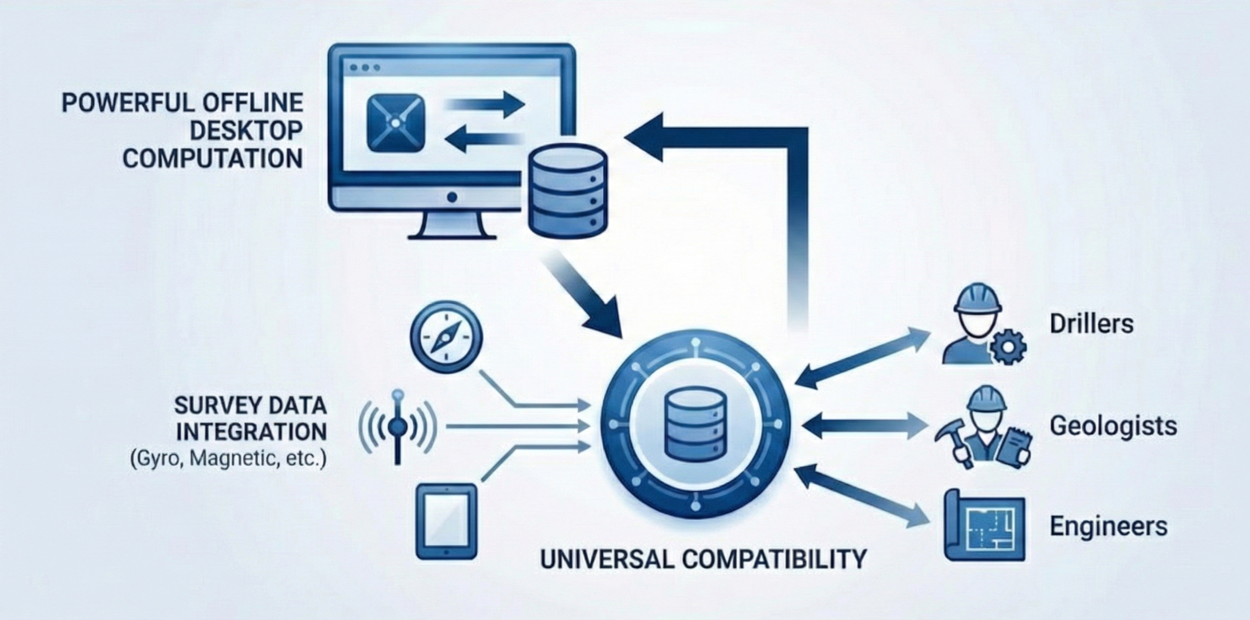
HolePlan™ was engineered to resolve this friction by providing a completely vendor-neutral workspace. Unlike traditional platforms, it acts as a centralized data hub where all stakeholders can integrate data from any provider into a spatially accurate 3D environment.

The software architecture of HolePlan™ makes it a unified platform for drilling intelligence.

The software architecture of HolePlan™ makes it a unified platform for drilling intelligence.

A Foundation of Positional Accuracy and Universal Capability

To effectively integrate drilling data, it is essential to start with a standardized reference frame. The use of a globally recognized coordinate system like UTM and including automated Grid North correction is crucial. For instance, at a depth of 1,500 m, an uncorrected grid north error of just 1.5° can result in 40 m of horizontal displacement. By handling this correction at the architectural level, HolePlan™ ensures that all trajectories remain consistently referenced.

A platform supporting both Metric and Imperial units is a first step to real data sovereignty. The vendor-neutral solution allows all historical survey data — whether collected with magnetic tools today or high-precision gyros tomorrow — to remain in a unified, accessible format.

Seamless Data Capture

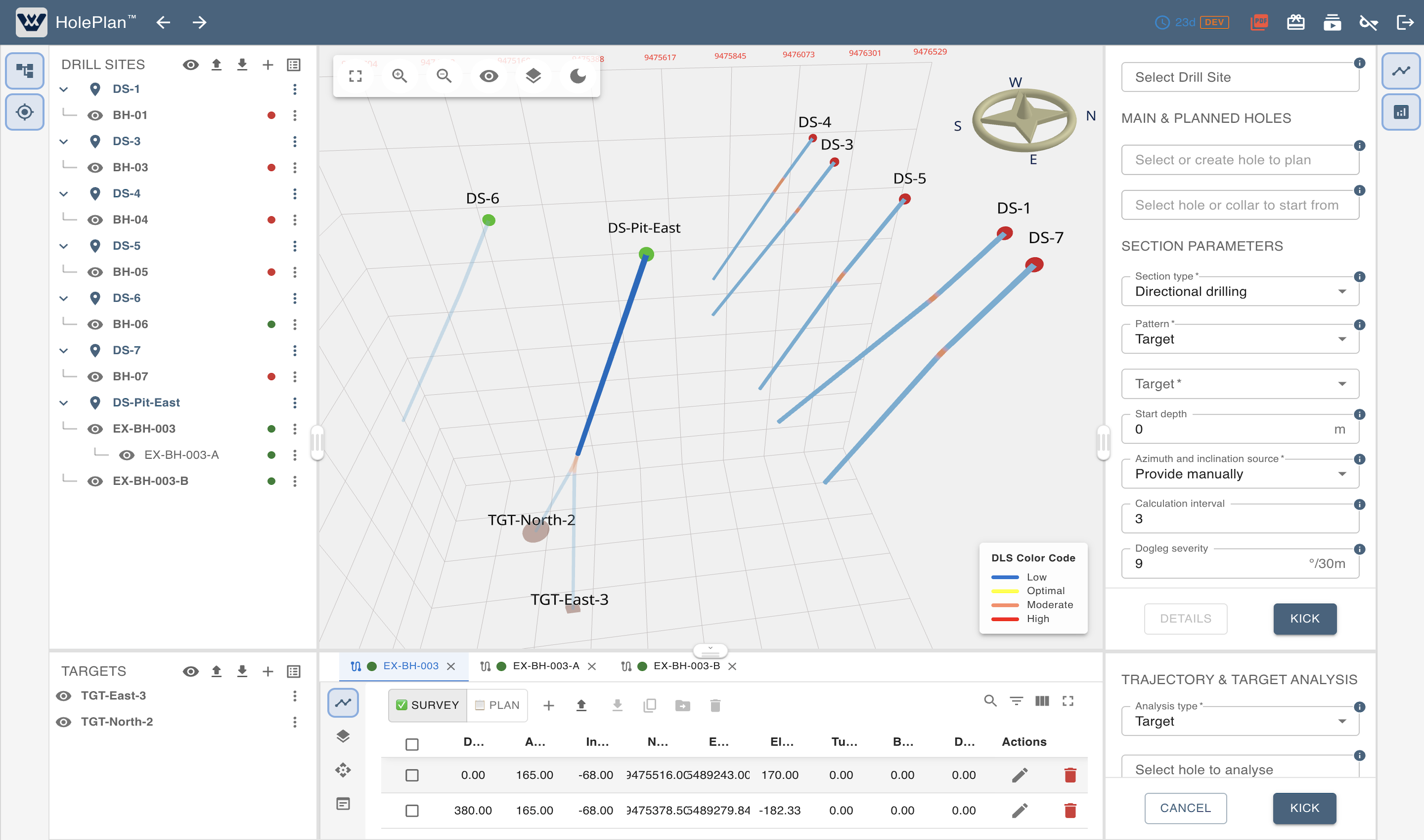
Once drilling begins, a centralized survey data management panel serves as the primary record for each drilled interval: trajectory measurements, lithology, downhole components, and target definitions in a range of shapes and dimensions. Data can be entered manually or synchronized in bulk through simplified Excel or CSV templates, eliminating the double-handling of information that typically fragments field records.

The Survey Data Management Panel provides instantaneous feedback on the 3D view.

The Survey Data Management Panel provides instantaneous feedback on the 3D view.

From Plan to Execution: A Continuous Workflow

Unlike most drilling software that treats planning and execution as separate activities, HolePlan™ provides a consolidated engineering framework that connects them into a dynamic continuous workflow. The journey begins with trajectory design, moves through field data capture and extends into real-time deviation analysis and equipment protection, with each phase seamlessly transitioning into the following one.

Intelligent Planning

Precision starts with selecting the right trajectory model for the ground conditions at hand:

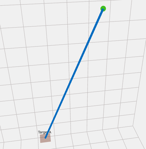
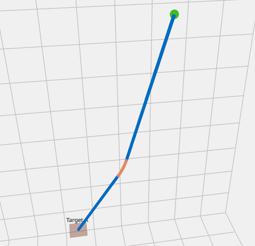
  • Straight Hole determines the direct path to the target and establishes the precise rig alignment required to ensure the borehole begins along its correct planned direction.
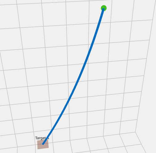
  • Natural Deviation integrates empirical Build and Turn data from sections drilled earlier to generate a pre-aimed path that reflects observed geological trends.
  • Directional Drilling supports the design of complex deviated trajectories using industry-standard API algorithms, with universal control over hydraulic, mechanical, and wedge-based deviation systems.

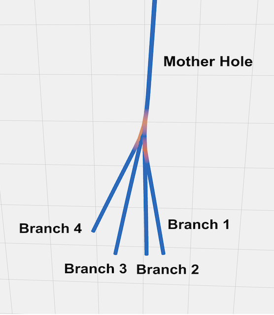
The multi-branch planning capability allows engineers to design paths where several branches deviate from a single mother hole — collaborating directly with directional drilling contractors within the same project environment.

Straight hole model

Straight hole model

Natural deviation model

Natural deviation model

Directional drilling model

Directional drilling model

Multi-branch planning capability

Multi-branch planning capability

Meter-by-Meter Deviation Analysis

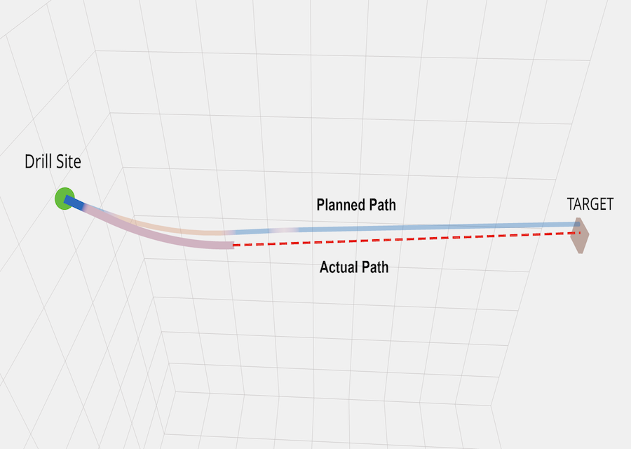
As survey data accumulates, comparing the actual borehole path against the planned trajectory at every meter becomes crucially important. Continuous Path-to-Plan Analysis lets engineers track whether the hole remains within the defined trajectory tolerances and predict how emerging deviations will develop under various scenarios. This transforms reactive decision-making into proactive steering control.

Continuous path-to-plan analysis

Continuous path-to-plan analysis

Safety and Equipment Protection

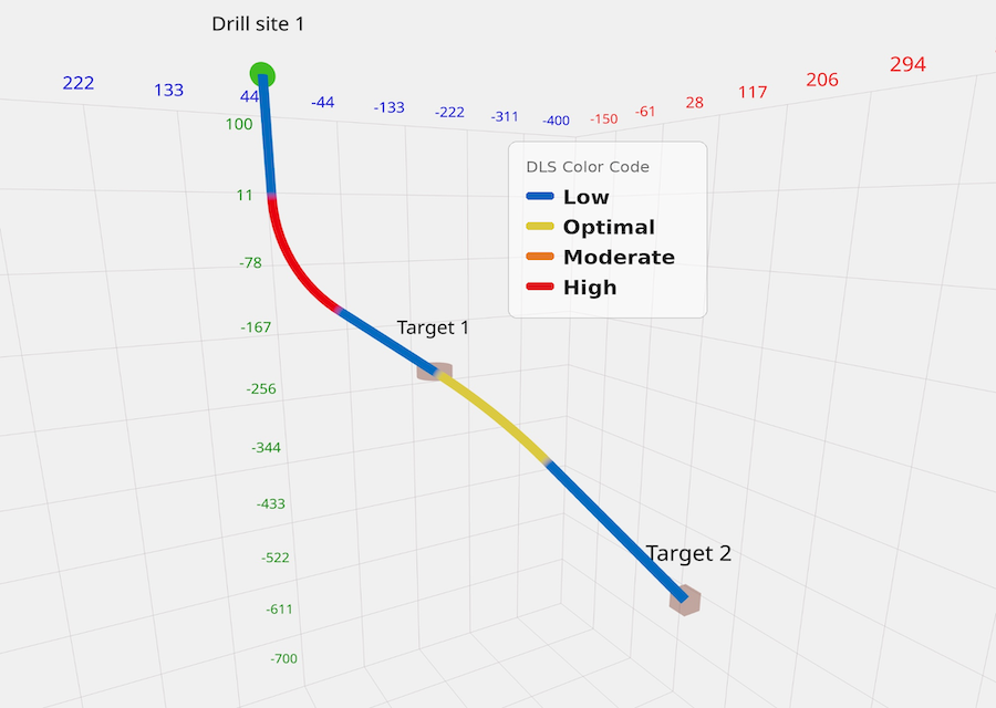
The workflow closes with a safety layer that applies rod specifications, CDDA values, and engineering input to the accumulated trajectory data. HolePlan™ incorporates real-time dogleg severity (DLS) color-coding directly onto the 3D trajectories to highlight intervals of high curvature where fatigue or twist-off risk is elevated. By visually flagging curvature rates, the software provides an instant risk analysis, helping protect both the drill string and the project budget before problems occur underground.

Real-time dogleg severity (DLS) color-coding

Real-time dogleg severity (DLS) color-coding

Engineered for Remote Reality

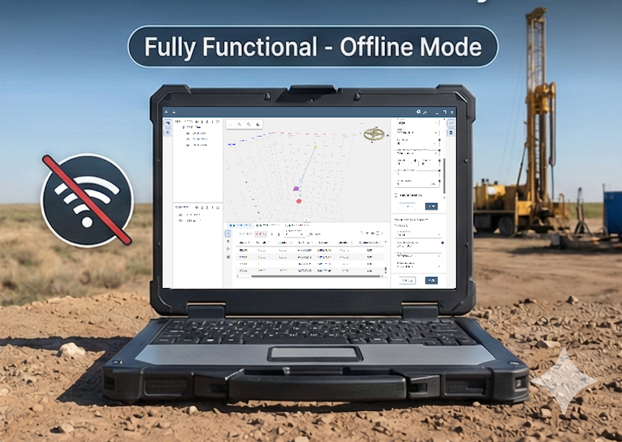
Exploration drilling often happens in the world's most challenging environments — regions where digital infrastructure is non-existent, and a stable internet connection is often a luxury. In the context of these harsh field realities, a desktop engine offers a more reliable and field-ready foundation for drilling operations than a cloud-dependent platform.

HolePlan™ is built on a high-performance desktop engine, designed to operate on field workstations. By processing all 3D visualizations and complex trajectory calculations locally, the software ensures that engineers maintain a continuous, uninterrupted workflow even at the most remote sites on Earth. A system built on the belief that a connection should be a bonus, not a requirement.

100% offline power for remote operations

100% offline power for remote operations

HolePlan™
A Platform for the Entire Value Chain

HolePlan™ is designed as a vendor-neutral and data-centric engineering environment, with its utility extending across the industry:

  • Resource companies retain centralized ownership of all survey and trajectory data, eliminating the need to migrate records between vendor-specific cloud platforms when survey tool providers change.
  • Drilling contractors operate within a structured environment for managing tool compatibility records, lithology logs, rod size intervals, and downhole accessories, improving coordination between field operations and engineering oversight.
  • Directional drilling specialists work with established algorithms compatible with all tool types, making optimal steering decisions without software constraints.
  • Civil engineering teams apply the same 3D spatial precision to urban projects, pilot holes, and tunneling — operations where subsurface accuracy is critical.

By serving each stakeholder within a unified framework, HolePlan™ supports collaboration without sacrificing data ownership or operational independence.

True Accessibility: Empowering Every Stakeholder

We believe advanced drilling software should be accessible to every participant in the exploration process. Our pricing model is designed to remove traditional cost barriers, enabling independent drillers, field geologists, and global mining organizations alike to adopt modern, high-precision tools without complex licensing. The result is faster adoption, broader collaboration, and measurable operational value across the entire drilling cycle.

Looking Ahead

As exploration targets become deeper and more complex, the need for independent, flexible, and precise software tools has never been greater. HolePlan™ isn't just a new software tool; it is a shift toward a more open, transparent, and safe drilling industry.

The initial release of HolePlan™ establishes its foundation, but the architecture is designed for continuous development. By unifying exploration drilling data into a single, client-controlled platform, HolePlan™ gives engineers something that fragmented systems never could: a complete operational picture, accessible anywhere, controlled by the people who need it most.

Originally published as "HolePlan Trajectory Design Software: Drilling Intelligence Without Borders" in Coring Magazine. Read the original article on Coring Magazine ↗